Members Event, Eno River, 6/7 October
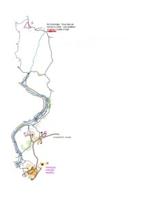
UPDATE: The footbridge that crosses the small creek on the way to the camping area is closed because of hurricane damage. Don’t plan on crossing this stream via the southern route — instead use the northern route (see map below).
On Saturday and Sunday October 6 & 7, BOK will hold two Member events at Eno River State Park: a Saturday night-O; and a Sunday morning classic event. Attend one or both; but note that attending the night-O on Saturday will require camping out at the park. These events are open to BOK members who have completed an orange (or more advanced) course as well as to members of other orienteering clubs and to active members of the US military. You must pre-register for each event using the form below, preferably well before 5:00 PM on Friday, October 5th, so that we know how many maps to print. Starts for the Saturday night-O will be between 8:00 and 9:00 PM. Starts for the Sunday event will be between 9:30 AM and 1:00 PM.
Getting there
Parking: If you are participating in the night event, you must: (a) check-in with the park office on arrival to get an overnight parking pass; (b) park in the overnight parking area (GPS coordinates = 36.074228, -79.004550); and (c) carry your camping gear to the campsite. Unless you want to make a 5 km round trip hike, do not plan on visiting your car again until you are done orienteering.
If you are only participating in the Sunday event, park (in order of proximity) either at the Visitor Center (GPS = 36.078290, -79.004716), the Piper Cox lot (36.077903, -79.007279) or the Fews Ford loop parking lot (GPS = 36.073798, -79.006108). Please leave enough time to hike the 2.5 km from the parking area to the registration. See the locator map below for more information about parking and registration locations.
Start/Camping: Both the night and the day courses will start near the Buckquarter group campsite at Eno River State park. This is not the same campsite that we have used in the past, but rather one that is much further to the north. See the map above for how the campsite can be accessed, and note that it is nearly a 2.5 km hike from the parking area to the campsite. Note also that the easiest way to access the camp involves a stream crossing without a footbridge. With low river levels, it is easy to stay dry on this crossing by stepping on stones. If the water is high though, consider taking the alternative route, using the southern stream crossing, which has a footbridge (see map above).
BOK has reserved this campsite for Saturday night. Because the park closes its main gate at 9:00 PM, anyone participating in the night-O needs to plan on camping at the group camp site. There is no parking outside of the park within easy walking distance of the event. The group camping area has seven large, flat campsites, and will accommodate only the first 32 people who register. If more than 32 people register for the night-O, they may be able to reserve an individual campsite from the park on the other side of the river (click here for details). There is no plumbing, electricity, or showers at these campsites, but there is a primitive bathroom. The average overnight low temperature for this time of year is historically approximately 53oF, with a historic low of 35oF.
Course and map information
Maps for each event will be printed at a scale of 1:10,000. Control descriptions will be printed on the map — there will not be loose control descriptions. Please contact the event director before 02 October at dw.orienteer@gmail.com to request a map with a different scale.
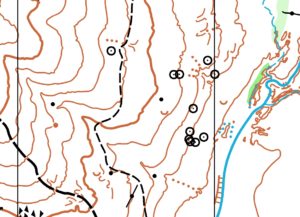
The map for these events is a brand new LIDAR-based effort of the north side of Eno River State Park. It provides some exquisite contour detail, and a number of historically interesting sites (contour interval = 5m). A representative map snippet is below.
Sunday Night-O Courses. The start window will open at 8:00 PM; astronomical twilight starts at 7:47 PM. The moon will be a waning crescent, rising at 4:13 AM. It will thus be quite dark for this event. Obviously, you will need to carry a light source, such as a headlamp or flashlight for the night event. Please also take a whistle. Note that the technical difficulty of the expert night courses will be comparable to a brown or green daylight course. In particular, this course will pose significant navigational challenges and some steep rocky terrain. Those who prefer relatively easier control placements at night are thus strongly advised to do the intermediate course, which would be comparable to a yellow/orange course during the day. Controls on the night course will have reflective strips on them to enhance their visibility. There will not be purposeful decoy controls on the night courses; however, competitors may see Sunday controls (without reflective tape) that are not on their course. The meet director has not yet decided whether there will be drinking water available on the night courses. Competitors should thus plan on being responsible for their own hydration.
Sunday Classic-O. This will be a typical advanced event on a 1:10,000 map, with brown, green, and red course options. The courses will mostly feel like a longish middle-distance race; however, each will have at least one long leg. The meet director has not yet decided whether there will be drinking water available on these courses. Thus, competitors should plan on being responsible for their own hydration.
Course Summary
| Time | Course | Length (km) | # of Controls | Climb (m) |
| Saturday night | Intermediate | 2.9 | 9 | 125 |
| Advanced | 4.2 | 10 | 225 | |
| Sunday morning | Brown | 3.9 | 10 | 185 |
| Green | 5.6 | 14 | 275 | |
| Red | 7.0 | 18 | 340 |


