Birkhead Hiking Challenge

Created in 2013 by Ranger Fox, the Birkhead Hiking Challenge (BHC) is a special type of geocache known as a multi-cache. At over 40 miles, it is one of the longest. Each cache is a small camouflaged container buried under rocks that provides coordinates to the next. The BHC is an uncharted tour of the 5,160-acre Birkhead Mountains Wilderness that reveals itself along the way.
Since 2013, only about 10 people have completed this challenge. Before Kevin McCabe’s 2/28/26 completion, all people used GPS to do so. In December 2025, BOK devised maps for a variation of the BHC that foregoes GPS in favor of navigating with just map and compass. Dubbed Birkhead Unplugged, it’s a lot harder than traditional geocaching, but not impossible.
BHC is not an organized event. Go when you please and hike your own hike. You may choose to share your results, or not. Please do not post any spoilers, or GPS tracks. This page is set up as a record of Unplugged attempts past, present and future. All information here is based on the honor system. Email me with updates. Next BOK BHC “mass start” on 4/4/26, see below. If you can’t make it, don’t worry, the BHC is still out there waiting for your visit!
| Name(s) | Date(s) | Status | Caches Found | Cumm. Distance | Cumm. Time | Notes |
| Kevin McCabe | 2/27-28/26 | Finished! 100% no GPS | 16/16 | 58.5 miles | 29h55m | First unplugged completion |
| Carl Laniak | 12/13/25, 4/4/26(?) | Unfinished, 100% no GPS | 7/16 | 28 miles | 11h40m | First unplugged attempt |
| Matt Kirk | 12/13/25, 4/4/26(?) | Unfinished, 100% no GPS | 7/16 | 28 miles | 12h15m | First unplugged attempt |
What: navigate over 40 miles throughout Birkhead Mountains Wilderness to complete the Birkhead Hiking Challenge (BHC) unplugged i.e. without GPS. Each of the 16 hidden caches provides coordinates to the next.
When: Saturday, April 4th 2026 as part of BOK weekend. Check-in and map handout begins 6 am. Return to start/finish no later than 3 pm Sunday, April 5th when BOK events conclude (32-ish hour time limit). Alternately, go when you please.
Where: Start/Finish at Gray Owl for registered BOK participants (N 35° 37.910 W 79° 52.930), or Tot Hill TH (N 35° 38.184 W 079° 54.279) for those expecting to take longer than 32 hours, or going at another time.
Cache 1 coordinates: N 35° 37.033 W 079° 54.250
Who: open to self-sufficient navigators. You are responsible for your own safety.
How: read this geocache page created and maintained by Ranger Fox. Use print maps to plot coordinates in degree, decimal minutes (DDM). Navigate self-sufficiently with these maps and compass for up to and possibly over 32+ hours in the wilderness. You should carry GPS (i.e. phone plus external battery) for safety, but you are challenged to NOT use it for navigation. Please refrain from publishing route data.
Maps: there are currently two BHC orienteering map sets. The “old” 1:15,000 set has 5m contours oriented to TN and 0.1 min DDM grid (angled 500m MN meridians) and is three 8.5×14 pages plus one 8.5×11 page. The “new” 1:10,000 set has 5m contours oriented to MN with 500m MN meridians (angled 0.1 DDM grid) and is nine 8.5×11 pages plus cover sheet with lat/long scale for measuring 0.01 minute.
To order digital and/or print copies of these maps, click the link below. Important to note that the new set of maps uses very tight margins with a 9mm overlap, so check printer settings carefully. Both sets have advantages and disadvantages. The old set is easier to manage (fewer pages) and likely faster to plot and navigate with for longer distances. The new set is produced with a much higher quality resolution and at a larger scale for attacking ground zeroes with better accuracy. For whatever it’s worth, Kevin used the old set. For those ordering prints, maps are printed in color on standard 20 lb. non-waterproof paper (protect your maps). Be sure to order print maps one week prior to map handout (i.e. 4/4/26 Gray Owl) to ensure they are ready.
More map info: the magenta border line in the west of each map set indicates the Thornburg Farm area. For this area, only contour lines are georeferenced. All other mapped objects in Thornburg (e.g., trails, boulders, stream bends, etc.) are not georeferenced. They may be mapped with 0-30 meters of inaccuracy.
Example: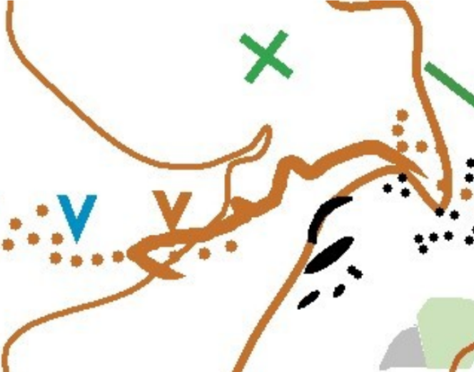
In this image, note how the mapped gully does not lie within the mapped reentrant. In this case, the reentrant (i.e., contour line) is what’s georeferenced. The mapped gully can still inform you about its shape. You can also assume that the nearby rock features are also displaced south by about the same amount as the gully.
On all portions of the map other than Thornburg Farm, every mapped feature is georeferenced. Bottomline: as imperfect as they are, these maps are proven to work for BHC Unplugged. If you want, you can always make and use your own maps. Enjoy the challenge!